Nine Arch Bridge: Ella's Jungle Viaduct, and How to See It Properly
By Sahan Kalpa Dayarathna · · 6 min read
- Province
- Uva Province, Badulla District
- Nearest town
- Ella, a 30–45 minute walk
- Completed
- 1921, during British colonial rule
- Dimensions
- About 91 m long and 24 m high, on nine arches
- Line
- Colombo–Badulla railway, between Ella and Demodara
- Best time
- Early morning, before the midday haze and crowds
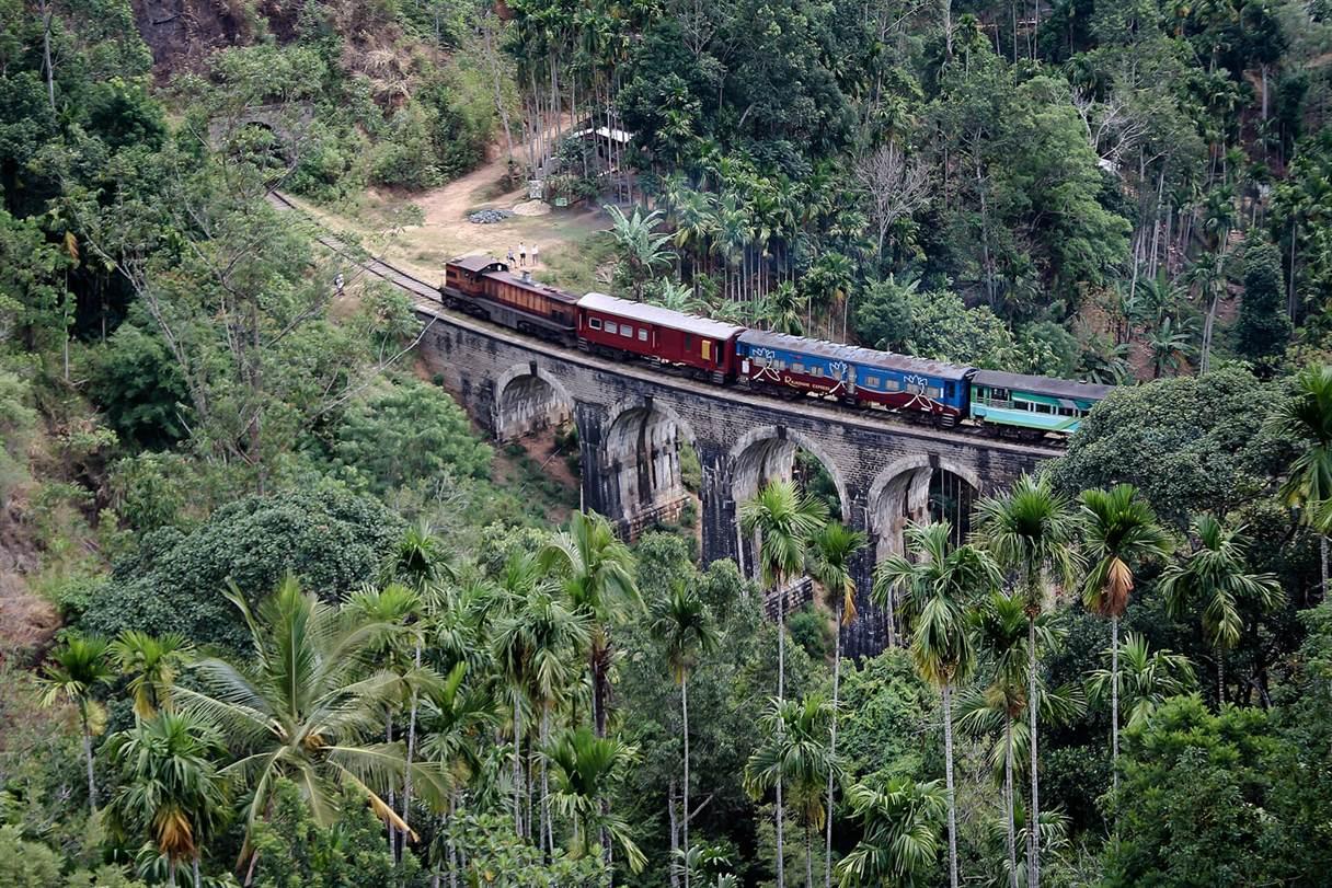
The Nine Arch Bridge is the photograph everyone wants from Ella: a long stone viaduct curving through dense green jungle, with a blue train crawling across it. It is also a working piece of railway infrastructure on a line that still carries passengers up to Badulla, which is the first thing to understand before you go looking for the shot.
The bridge is genuinely beautiful, but the experience depends almost entirely on timing. Arrive at the wrong hour and you will find a crowd of tripods, a few cows and no train. Arrive at the right one and the whole valley seems to hold its breath for the thirty seconds it takes the carriage doors to pass.
Why the bridge exists
The railway from Colombo climbs into the highlands through some of the steepest terrain on the island. Between Ella and Demodara, the line has to lose height quickly, so the engineers built a spiral: the track loops back under itself and emerges lower down the valley. The Nine Arch Bridge is part of that solution, carrying the line across a gap between two hills.
The bridge was completed in 1921. The story most often told locally is that the steel intended for it was diverted to the war effort in Europe, so the engineers built it from stone, brick and cement instead. Whether or not every detail of that story holds, the result is unusual: a solid, arched viaduct that looks older than it is, softened by a century of moss and jungle.
Three ways to reach it
The simplest is to walk. From Ella town, head down the road past the railway station and follow the signs towards the bridge. The route takes thirty to forty-five minutes at an easy pace, mostly downhill on the way there and mostly uphill on the way back. It passes small guesthouses, tea bushes and a couple of places selling king coconut, and it is a pleasant walk in the morning before the heat builds.
The second option is a tuk-tuk to the car park near the bridge, then a ten-minute walk along a track. Drivers know the spot and will usually wait. Expect to pay a small fee to cross private land on some routes; this is normal, and the money goes to the landowners rather than the railway.
The third option is the most satisfying if you have the time: take the train from Ella to Demodara, get off, and walk back to the bridge along the road. The journey is short, the scenery is excellent, and you arrive with a better sense of how the line stitches the hills together. Check the return times at Ella station before you set out, because the service is infrequent.
- Walk from Ella town: 30–45 minutes each way, mostly on quiet roads and tracks
- Tuk-tuk to the car park: 10 minutes on foot from there, easiest with luggage or children
- Train to Demodara and walk back: the most scenic option, but check return times
When the trains actually cross
There is no single fixed timetable that stays true for long. Several services pass each day in each direction, with a cluster in the mid-morning and another in the afternoon. The mid-morning service is the one most photographers aim for, which also makes it the most crowded.
The reliable approach is to ask at Ella station or your guesthouse the day before, then arrive at the bridge at least thirty minutes before the stated time. Trains run late, and the good positions on the hillside fill up. If you are staying two nights, consider checking the bridge on one day and returning on the next at a quieter hour.
Do not rely on a timetable you found online months ago. Services are added, cancelled and retimed, and the difference between a serene morning and a wasted one is usually a five-minute conversation with someone local.
Where to stand, and what makes a good photograph
The classic view is from the hillside above the tracks on the Ella side, looking along the curve of the viaduct with the jungle behind. A path leads up from the road to several natural platforms, some with a small café and a rope barrier. Buy a drink if you use a café terrace; it is how these places survive.
The light is best early. By late morning the valley fills with haze and the sun climbs behind the bridge, flattening the stone. If you want the train in the frame, position yourself so the track curves away from you rather than across you — the curve is what makes the bridge look long.
The trackside view, standing close to the rails, is the one to avoid. People do it, and it produces dramatic photographs, but the bridge is a working railway with no barrier, a serious drop and a train that arrives quietly around a curve. The hillside view is safer and, in most light, better.
Safety, etiquette and what to wear
Wear shoes with grip. The paths are muddy after rain, the grass is slippery, and the slope above the tracks is steeper than it looks in photographs. Carry water and a rain jacket; the hill country can turn from sun to mist in twenty minutes.
Do not walk on the bridge or along the tracks. Do not sit on the edge of the viaduct for a photograph. Keep children close, and keep an eye on the drop if you are shooting from the upper path. Leeches are common in the wetter months, so tuck trousers into socks if you are walking through long grass.
The bridge is free to visit, but some access routes cross private land and carry a small fee. Vendors sell tea, snacks and king coconut near the main viewpoints. Take your rubbish out with you — the area is a village, not a managed attraction, and the litter problem is visible on busy days.
What to pair it with
The bridge sits neatly between Ella town and Little Adam's Peak, so a morning walk can combine all three: bridge first, then the ridge, then breakfast back in town. The climb to Little Adam's Peak takes about forty-five minutes from the trailhead and gives you a view back over the valley and, on a clear day, towards the southern plains.
Ravana Falls is a short tuk-tuk ride away, and the Demodara loop — where the track passes under itself — is a curiosity for anyone interested in the railway. A tea factory visit fits the same day, and Ella's cafés are good enough to justify a long, slow lunch afterwards.
Give Ella two nights if you can. The bridge is the headline, but the town works best as a base for the surrounding hills rather than a single photo stop.
Frequently asked questions
- How far is the Nine Arch Bridge from Ella town?
- About 2.5 km, or 30–45 minutes on foot, mostly downhill on the way there. A tuk-tuk takes around ten minutes to the car park, followed by a short walk.
- What time do trains cross the Nine Arch Bridge?
- Several services cross each day, mostly in the mid-morning and again in the afternoon. The mid-morning train is the most popular with photographers. Times change, so confirm at Ella station or with your guesthouse the day before.
- Is the Nine Arch Bridge free?
- Viewing is free. Some walking routes cross private land and charge a small fee, and café terraces expect you to buy something if you use their view.
- Can you walk across the bridge?
- You should not. It is an active railway line with no barrier and a significant drop, and trains approach around a blind curve. Use the hillside paths above the tracks instead.
Written by
Sahan Kalpa DayarathnaSahan Kalpa Dayarathna is the editor of Discover Sri Lanka, based in Colombo. He writes the province guides, hotel picks and practical travel advice on this site, and updates them as transport, prices and opening times change.
Story filed 11 May 2026 about Nine Arch Bridge. Explore more in Uva Province.
More traveller stories
18 May 2026
Ravana Falls: Ella's Roadside Waterfall and the Legend Behind It
A tall cascade beside the Ella–Wellawaya road, tied to the Ramayana and best seen after the rains.
25 May 2026
Lipton's Seat: Sunrise Over Sri Lanka's Tea Estates
The hilltop where Sir Thomas Lipton surveyed his tea empire — and one of the best sunrise views in the highlands.